Urgent Warning as Hurricane Humberto Strengthens to Category 4

© Generated by Recraft
Meteorologists have confirmed that Hurricane Humberto has intensified to a Category 4 storm, sending fresh alerts across parts of the Atlantic and coastlines. Previously tracked as Tropical Storm Humberto, its upgrade underscores how rapidly conditions have escalated and marks a critical shift in risk for coastal regions.
Forecasts indicate that while Humberto is not expected to make landfall on the U.S. East Coast, it will generate life-threatening swells, rip currents, and rising seas along heavily populated shorelines. Authorities are urging people from Florida through the mid-Atlantic to monitor updates closely.
What Category 4 Means & Potential Impact
A Category 4 hurricane is labeled “catastrophic” for a reason: sustained winds of at least 130 miles per hour (and higher gusts) are capable of serious damage. Officials warn that “well-built framed homes” may lose major roof sections or even walls. Trees and power poles can be uprooted, causing widespread outages.
Even away from direct landfall, coastal communities are likely to feel effects. The storm is expected to produce dangerous surf, flooding in low-lying areas, and significant disruptions to marine and coastal transit. Warning systems and emergency protocols are being activated in vulnerable zones.
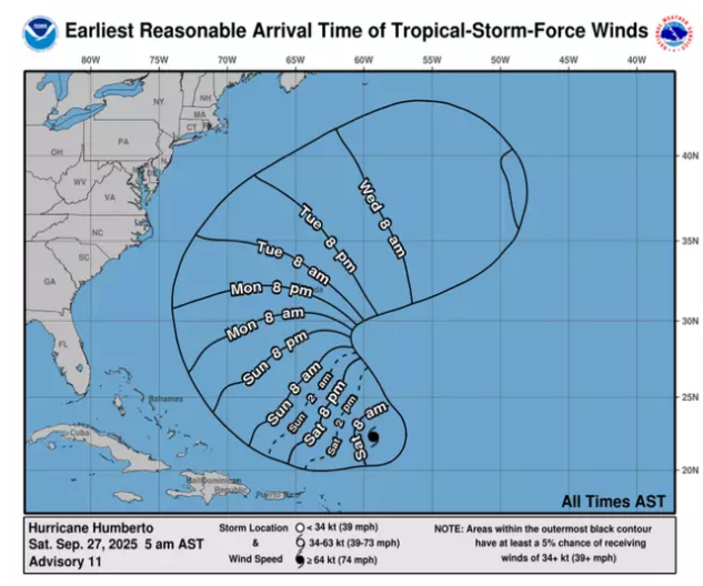
Forecast Track & Storm Behavior
Humberto is projected to sail between Bermuda and the U.S. East Coast, curving northeast as it moves away from land. Though the worst of it may pass offshore, its influence will still ripple outward through waves and unstable sea conditions.
At the same time, forecasters are keeping a close eye on a second system, Tropical Depression Nine (soon to possibly be named Imelda), which is forming closer to the U.S. It’s still developing, but its potential path includes approaches to Florida and the Carolinas early next week.
Given the proximity of these systems, there’s speculation about whether they might interact via the Fujiwhara effect, a rare storm “dance” in which two tropical cyclones rotate around one another, possibly altering paths or intensities.
What Authorities Are Doing
While no U.S. coastal warnings are currently in effect, regions from Florida to the mid-Atlantic are being urged to “stay informed this weekend.” Emergency agencies are preparing protocols for flooding, evacuations, and power restoration.
In the Bahamas and select Caribbean territories, warnings for parts of the central and northwestern islands have already been issued. These areas are expected to receive significant surf and rain as Humberto pushes the sea swell outward.
Officials continue to emphasize that even without a direct strike, indirect effects can still be dangerous. Coastal residents are advised to avoid swimming, boating, or venturing near the water until conditions stabilize.
Conclusion
Hurricane Humberto’s sudden upgrade to Category 4 marks a serious escalation in Atlantic storm activity. Though its path is expected to curve away from land, the hazards—strong surf, coastal flooding, rip currents—pose real risk for hundreds of miles of coastline. Meanwhile, the development of a second system (Imelda) raises uncertainty and complicates projection models.
This moment is a reminder: storms far offshore can still touch shores in dramatic ways. For coastal dwellers, vigilance and preparedness are the best tools.
You might also want to read: What’s Really Down There? The Great Blue Hole Shocks Scientists